 |
||||||||||||||||||||
NSF Program Announcement Research Activities MARGINS-NSF Awards Event Response Policy Data Policy Data Server Post-Doctoral Fellowships Related Websites
|
||||||||||||||||||||
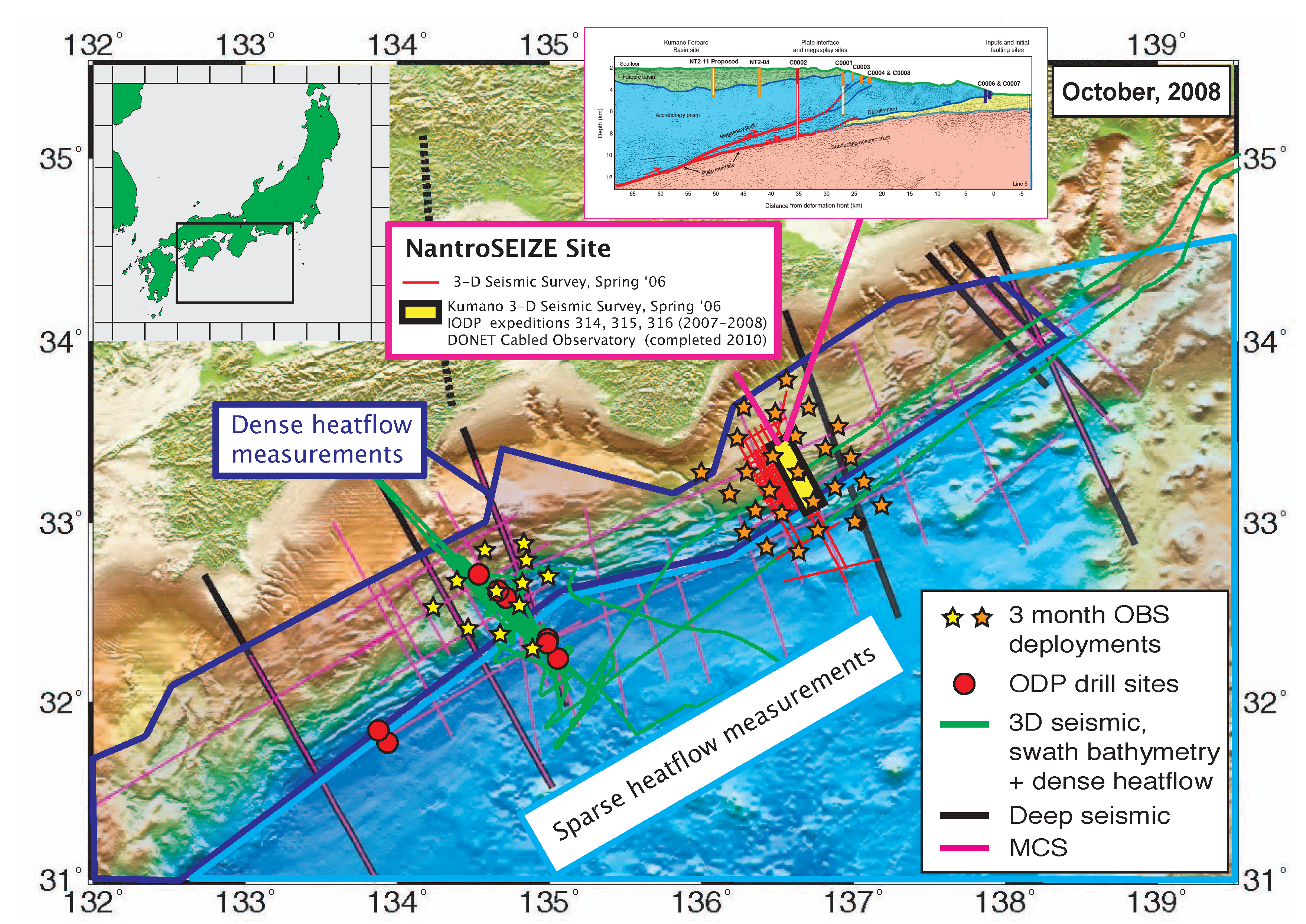
SEIZE Focus Site: Nankai
This page is the home for data, figures, references that are relevant to the Seismogenic Experiment (SEIZE) Initiative and the Nankai-Japan Trench focus area. If you have questions, suggestions, or if you want to submit data, please contact the MARGINS Office.
| Focus Areas: | Central America |
| Costa Rica-Nicaragua Focus Area Map | |
| Nankai Trough | |
| Nankai Focus Area Map | |
| Meetings: | SEIZE 2003 Theoretical Institute |
| Meeting pages contain abstracts, bibliographies, presentations, lecture notes and much more information. | NanTroSEIZE Workshop 2002 |
| Seismogenic Zone Experiment (SEIZE) workshop, Hawaii 1997 | |
| Documents: | SEIZE science plan |
| NSF-funded SEIZE awards | |
| Nankai Trough Seismogenic Zone Drilling and Observatory - IODP Proposal (October 2001) | |
| Graphics: | MARGINS Presentation materials |
| Earthquake maps and cross-sections | |
| Nankai figures | |
| Links: | University of Miami, RSMAS Geodesy Lab |
| NantroSEIZE Deep Drilling Proposal-New Mexico Institute of Science and Technology | |
| Seismic Reflection Data from Nankai and Central America at UTIG web site |
Nankai Trough Seismogenic Zone Drilling and Observatory - IODP Proposal October 2001
In response to the first IODP call for proposals, a preliminary proposal for Seismogenic Zone Experiment drilling at the Nankai Trough was submitted to iSAS in October, 2001. The proposal, largely developed at a workshop held August 10-12, 2001 in Tokyo, was submitted by the 40 member Nankai Trough Seismogenic Zone Research Group. It outlines a program of both riser and non-riser drilling designed to characterize the plate boundary thrust and associated splay faults from seaward of the trench to the up-dip end of the seismogenic zone.
Download the proposal as a PDF file (1.6 MB)
![]()
Here are some figures related to the Nankai-Japan Trench that are of interest. Please click on the thumbnails to see the enlarged version.
 Mantle wedge tomography across Honshu, Japan, after Zhao et
al. (1992). Earthquake loci are projected as small open circles, relative
mantle P-wave velocities are shown in colors, from red (slow) to blue
(fast). Note that there are two parallel zones of earthquakes, with the
upper one defining the upper part of the plate. Note that the zone of
“slow” mantle, inferred to reflect partially molten zones, lie
several tens of km above the subducted slab.
Mantle wedge tomography across Honshu, Japan, after Zhao et
al. (1992). Earthquake loci are projected as small open circles, relative
mantle P-wave velocities are shown in colors, from red (slow) to blue
(fast). Note that there are two parallel zones of earthquakes, with the
upper one defining the upper part of the plate. Note that the zone of
“slow” mantle, inferred to reflect partially molten zones, lie
several tens of km above the subducted slab.
 Effect of the subducted slab beneath Alaska on regional
seismic waveforms that travel along the subducted crust (Abers and Sarker,
1996). Red circles denote earthquakes at 100-150 km depth within the slab.
Seismograms recorded at COL are simple for P waves that do not travel
along the slab (green arrow), but pulse dispersion characterizes waves
that travel along the slab (red arrows). Inset shows structure needed
to produce this effect, a layer of subducted crust, ~5% slower than surrounding
mantle. Velocities are consistent with lawsonite blueschist (Helffrich,
1996) but not gabbro or eclogite.
Effect of the subducted slab beneath Alaska on regional
seismic waveforms that travel along the subducted crust (Abers and Sarker,
1996). Red circles denote earthquakes at 100-150 km depth within the slab.
Seismograms recorded at COL are simple for P waves that do not travel
along the slab (green arrow), but pulse dispersion characterizes waves
that travel along the slab (red arrows). Inset shows structure needed
to produce this effect, a layer of subducted crust, ~5% slower than surrounding
mantle. Velocities are consistent with lawsonite blueschist (Helffrich,
1996) but not gabbro or eclogite.
 Metamorphic facies for wet basalt, showing seismic P-wave velocities (km/s),
from Peacock (1993) and Helffrich (1996). Black lines show P-T trajectories
of subducting material for upper (UC) and lower (LC) crust. For comparison,
mantle peridotite should have velocities of 8.0-8.2 km/s under similar
conditions, and unaltered crust near 6.5 - 7.0 km/s. The seismic wave
distortion measurements shown in Fig. 8a are consistent with lawsonite
blueschist or with mixtures of eclogite and basalt.
Metamorphic facies for wet basalt, showing seismic P-wave velocities (km/s),
from Peacock (1993) and Helffrich (1996). Black lines show P-T trajectories
of subducting material for upper (UC) and lower (LC) crust. For comparison,
mantle peridotite should have velocities of 8.0-8.2 km/s under similar
conditions, and unaltered crust near 6.5 - 7.0 km/s. The seismic wave
distortion measurements shown in Fig. 8a are consistent with lawsonite
blueschist or with mixtures of eclogite and basalt.
