 |
||||||||||||||||||||
NSF Program Announcement Research Activities MARGINS-NSF Awards Event Response Policy Data Policy Data Server Post-Doctoral Fellowships Related Websites
|
||||||||||||||||||||
SEIZE and SubFac Focus Site: Costa Rica-Nicaragua
This page is the home for data, figures, references that are relevant to the Subduction Factory Initiative and the Seismogenic Experiment (SEIZE) Initiative and Costa Rica-Nicaragua focus area. If you have questions, suggestions, or if you want to submit data, please contact the MARGINS Office, who will be happy to try to help you.
Web Link:
Boston University
TUCAN Imaging Proposal
An NSF-funded proposal for PASSCAL Imaging of the deep mantle of the Central American Volcanic Arc Geoff Abers, lead PI
Full Text of Proposal
Project Summary
Instrument Deployment Map
Web Link:
University of Miami, RSMAS
Geodesy Lab Website
The Geodesy Laboratory is a research program within the Marine Geology and Geophysics Division of the Rosenstiel School of Marine and Atmospheric Sciences-UM. Satellite-based geodetic measurements are applied to a variety of scientific problems, including crustal deformation and plate motion, volcano monitoring, and coastal stability, in Central America, among many other places.
MARGINS Nicaraguan Volcanoes field guide
The excursion guide, by M. J. Carr, from the field trip held in connection with the MARGINS Workshop in Costa Rica in July 2001, is available in PDF format below, as well as an excerpt from Benjamin van Wyk de Vries' unpublished Ph.D. thesis at the Open University, Milton Keynes, UK from 1993, titled: "Tectonics and magma evolution of Nicaraguan volcanic systems"
- Margins Volcanoes Field Trip July 2001 Nicaragua (916 kB PDF file)
- Tectonics and magma evolution of Nicaraguan volcanic systems (excerpt, 1 MB PDF file)
MARGINS Costa Rica Fore Arc Tectonics field guide
The excursion guide, by J.S. Marshall, from the field trip held in connection with the MARGINS Workshop in Costa Rica in July 2001, is available in PDF format below.
Click here for more on Centam volcanoes (including pictures!) and geochemical data from Michael Carr's web page at Rutgers University: http://www-rci.rutgers.edu/~carr/index.html
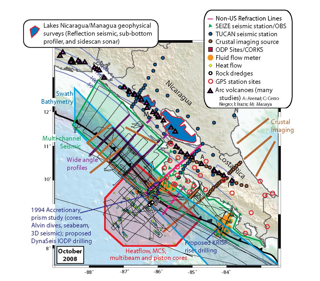
Here are some figures related to Costa Rica-Nicaragua that are of interest. Please click on the thumbnails to see the enlarged version in a separate browser window.
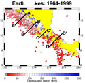 Costa
Rica-Nicaragua earthquake distribution maps and sections. Clicking
on the small map to the left will open a web page witth a clickable
map of the earthquake distribution between 1964 and 1999, with cross
sections showing the depth distribution. All maps and cross sections
can be downloaded as high-resolution EPS files from the web page.
Costa
Rica-Nicaragua earthquake distribution maps and sections. Clicking
on the small map to the left will open a web page witth a clickable
map of the earthquake distribution between 1964 and 1999, with cross
sections showing the depth distribution. All maps and cross sections
can be downloaded as high-resolution EPS files from the web page.
 Trenches (barbed lines) associated with convergent margins
of the Pacific, Caribbean, and eastern Indian Ocean. Red barbs identify
accreting margins, where the forearc is growing seaward by offscraping
of trench-floor deposits. Yellow barbs are non-accreting margins along
the base of with no modern growth of sedimentary prisms. About 44%
of Earth’s aggregate convergent margin length of 43,000 km is
non-accretionary and about 56% is accretionary. Each year a total of
about 1 cubic kilometer of upper plate material returns to the mantle.
Trenches (barbed lines) associated with convergent margins
of the Pacific, Caribbean, and eastern Indian Ocean. Red barbs identify
accreting margins, where the forearc is growing seaward by offscraping
of trench-floor deposits. Yellow barbs are non-accreting margins along
the base of with no modern growth of sedimentary prisms. About 44%
of Earth’s aggregate convergent margin length of 43,000 km is
non-accretionary and about 56% is accretionary. Each year a total of
about 1 cubic kilometer of upper plate material returns to the mantle.
 Map of the Central American convergent margin, showing the
location of volcanoes and DSDP site 495 and ODP sites 844 and 1039.
Map of the Central American convergent margin, showing the
location of volcanoes and DSDP site 495 and ODP sites 844 and 1039.
 Regional variation in Ba/La in lavas from
along the Central American arc. Ba/La is another monitor for the subduction
component. Filled symbols are samples from along the volcanic front.
Open symbols are back-arc samples. The back-arc samples in Honduras,
furthest from the volcanic front (open triangles), have low Ba/La and
are derived from depleted mantle and lack a subduction signature. Lavas
from western Nicaragua (magenta diamonds) show the maximum slab signal
(Ba/La up to 140 compared to normal mantle Ba/La =10-20).
Regional variation in Ba/La in lavas from
along the Central American arc. Ba/La is another monitor for the subduction
component. Filled symbols are samples from along the volcanic front.
Open symbols are back-arc samples. The back-arc samples in Honduras,
furthest from the volcanic front (open triangles), have low Ba/La and
are derived from depleted mantle and lack a subduction signature. Lavas
from western Nicaragua (magenta diamonds) show the maximum slab signal
(Ba/La up to 140 compared to normal mantle Ba/La =10-20).
 Variations of Ba/Th vs. U/La in lavas from
the volcanic front of Central America. Lavas from Nicaragua (diamonds),
El Salvador (squares), and western Costa Rica (crosses) define binary
mixing arrays between carbonate-dominated and hemipelagic-dominated
end members. Sources include the carbonate (Carb) and hemipelagic (Hemi)
sediment sections on the Cocos Plate and three depleted sources, a
depleted MORB source and an E-MORB source from Sun and McDonough (1989)
and an altered oceanic crust (AOC) estimate. Any triangle, formed by
mixing between the two sediments and any of the three depleted sources,
includes most but not all the lavas. Fluid extracted from AOC and Hemi
should have much higher U/La and thus may expand the triangle over
the observed range.
Variations of Ba/Th vs. U/La in lavas from
the volcanic front of Central America. Lavas from Nicaragua (diamonds),
El Salvador (squares), and western Costa Rica (crosses) define binary
mixing arrays between carbonate-dominated and hemipelagic-dominated
end members. Sources include the carbonate (Carb) and hemipelagic (Hemi)
sediment sections on the Cocos Plate and three depleted sources, a
depleted MORB source and an E-MORB source from Sun and McDonough (1989)
and an altered oceanic crust (AOC) estimate. Any triangle, formed by
mixing between the two sediments and any of the three depleted sources,
includes most but not all the lavas. Fluid extracted from AOC and Hemi
should have much higher U/La and thus may expand the triangle over
the observed range.
 Regional variation in U/Th along the volcanic
front of the arc. This ratio is a useful tracer for sediment subduction
in Central America because of the unusually high U content and U/Th
of carbon-rich hemipelagic sediments near the top of the sediment section
on the Cocos plate, as found at DSDP site 495.
Regional variation in U/Th along the volcanic
front of the arc. This ratio is a useful tracer for sediment subduction
in Central America because of the unusually high U content and U/Th
of carbon-rich hemipelagic sediments near the top of the sediment section
on the Cocos plate, as found at DSDP site 495.
